ATGVIDEO
Home
Hot video
Now watching
Search
News
Sport
Music
Games
Humor
Animals
Movies
Auto
Home
Bhaskar Reddy Pulsani
Bhaskar Reddy Pulsani
Latest Videos
PostgreSQL - SQL Shell - Important Commands
Panchayat Raj Department - Road Information System Project
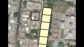
Singareni - Mine Lease Boundary Project
Rural Development Dept - Abadi Project for regularization of properties in abadi area of a village
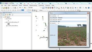
ArcGIS 10.x - Html Popup - Display Images in ArcGIS Destop with voice
The setup routines for the microsoft access driver *.mdb odbc driver could not be found
ArcGIS 10.x - Parcel Fabric - Hide the display of historic parcels - Method II
ArcGIS 10.x - Parcel Fabric - Hide the display of historic parcels
ArcGIS 10.x - Parcel Fabric - Show and symbolise historic parcels
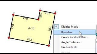
ArcGIS 10.x - Parcel Fabric - Splitting lines using the Breakline tool
ArcGIS 10.x - Parcel Fabric - Create donut or island polygon
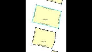
ArcGIS 10.x - Parcel Fabric - Explode multipart parcel
ArcGIS 10.x - Parcel Fabric - Create multipart parcel for disjoint parcels
ArcGIS 10.x - Parcel Fabric - Labeling parcel fabric layer
ArcGIS 10.x - Parcel Fabric - Easy way to copy and paste polygons to parcel fabric
ArcGIS 10.x - Parcel Editor - Delete Line Point
ArcGIS 10.x - Parcel Editor - Add Line Point
ArcGIS 10.x - Parcel Editor - Parcel Remainder
ArcGIS 10.x - Parcel Editor - Copy and paste polygons into parcel fabric
ArcGIS 10.x - Parcel Editor - Create new parcel using parcel editor
ArcGIS 10.x - Parcel Editor - Split parcels by proportional area
ArcGIS 10.x - Parcel Editor - Assigning sequential parcel numbers by drawing a line
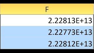
Excel remove e scientific notation from number
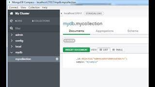
MongoDB Compass - Install software application for managing and viewing mongoDB data
mongoDB - Visual Studio - Install mongoDB drivers
PostgreSQL - Change the position of columns
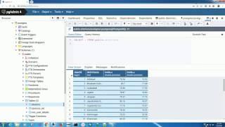
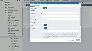
PostgreSQL - pgAdmin 4 - Import csv file - Method III
PostgreSQL - pgAadmin 4 - Import csv file - Method II
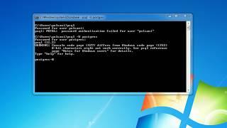
psql FATAL password authentication failed for user
PostgreSQL - PgAdmin 4 - Import csv file using PgAdmin
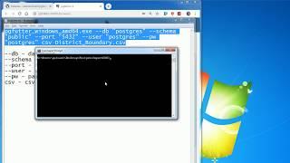
PostgreSQL - SQL Shell - Import csv file using cmd
PostgreSQL- pgfutter - Import CSV file along with headers
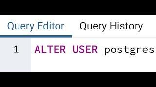
PostgreSQL - Change PostgreSQL password
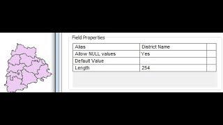
ArcGIS 10.x - Setting the alias name
ArcGIS 10.x - Alter Field - Rename fields of a shapefile
ArcGIS 10.x - Representation - Save symbology along with a feature class in GDB
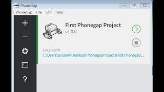
Install Phonegap desktop software and create project for mobile development
ArcGIS 10.x - Mosaic Raster data - Mosaic DEM
ArcGIS 10.x - Create Hillshade from DEM data
TanDEM-X - Download 90 Metre DEM Digital Elevation Model data
ArcGIS 10.x - Create Random Decimal Values - Python - Field Calculator
ArcGIS 10.x - Multi line and Multi color labels
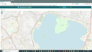
OpenStreetMap - Download OSM map as PNG - Workaround solution by hacking the browser
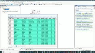
ArcGIS 10.x - Join Excel data with shapefile
ArcGIS 10.x - Delete multiple fields of a shapefile attribute table
Geocoding - Extract latitude and longitude for large dataset from Google Maps using Fusion Table
ArcGIS 10.x - Failed to delete object from SDE - Lock request conflicts with an established lock
SQLite - Download and install ODBC drivers for SQLite database
MySQL - Set up a connection to MySQL database using ODBC Data Source Administrator
MySQL - Download and install ODBC drivers for MySQL database